 Aldea de Ramaditas, Chile: Architectural Art or Rock Art? Aldea de Ramaditas, Chile: Architectural Art or Rock Art?
Maarten van Hoek rockart@home.nl
INTRODUCTION
First it will be necessary to define
architectural art and rock art. Architectural art comprises all art forms
(engravings, sculptures, paintings etc.) that have intentionally been made to exclusively
adorn surfaces of anthropic (humanly made) constructions.
Fine examples of architectural art are the engravings at Cerro Sechín in
northern Peru. Also the zoomorphic
images made up by small stone blocks built in into the stone terraces at
Choquequirao, an archaeological complex west of the city of Cusco, Peru, must
be regarded as architectural art and not as rock art, despite the unwanted
manipulation of the definition of rock art by Echevarría López &
Valencia García and despite the
uncritical acceptance of their paper in Rock Art Research (2009: 213). On the
other hand, rock art is the corpus of imagery (mainly petroglyphs and
rock paintings) that is found on natural rock surfaces (boulders and outcrop).
In the Andes of
South America it is not uncommon to find true rock art very near prehistoric structures,
but in relation with the hundreds of rock art sites in the Andes those
instances must be regarded to be erratic. Some rock art sites are only very
close to ancient structures, like the group of petroglyph boulders at Quebrada
de San Juan, Virú, northern Peru. In some cases petroglyph boulders are found
distributed among the ruins of ancient structures, like at Tomabal in northern
Peru (Van Hoek 2007) and at Rincón del Toro, La Rioja, Argentina (Van Hoek
2011). Some boulders at those sites (only?) seem to be part of the ruined walls. In other cases petroglyph boulders definitely form part of the ancient
structures, like at El Tambo in the Quebrada de la Guitarra in the Moche
drainage, northern Peru. Also in the Atacama Desert of northern Chile several sites feature decorated rocks that are part of
prehistoric structures, for instance the settlements of Tarapacá Viejo,
Camiña and Jamajuga (Vilches & Cabello 2006; Uribe 2006),
Vinto, Millune and Achuyo (Valenzuela,
Santoro & Romero 2004), and Suca (Sepúlveda, Romero & Briones 2005). Possibly three petroglyph
boulders originally were once associated with the structures of the ‘Pucará’ at San Lorenzo (AZ-11) in the
Azapa Valley of northern Chile. These boulders are now located at the Museo Arqueológico San Miguel de Azapa opposite
the “Pucará’ (Briones & Varela
2006).
Although there
are instances where true rock art has
been executed on the walls of ancient buildings (long) after the construction, for instance in Egypt (Van Hoek 2009), in
most cases the Andean examples most likely represent situations were petroglyph
boulders already occurred at the site (most evident at Tarapacá Viejo) and were
primarily and conveniently used as building material at the time of construction. This however does not rule out the
possibility that the ancient images were still venerated at and after the time of construction and
therefore they were so placed that they remained visible. Yet, this may also
have been done purely because of decorative motives.
I now argue that
in every single case in which a boulder
with rock art forms part of a prehistoric construction it should be ascertained
if that boulder has been used solely for building purposes or not. In most
cases those decorated boulders in ancient walls form the base of that wall, which argues in favour of being used as building
material. Unfortunately, many structures are too derelict and too much
disturbed to ascertain the original position of the decorated boulders. Also,
many of such boulders are rather large and will have readily been discarded as
building material. For instance, at Jamajuga in the Quebrada de Mamiña, Chile, several
boulders with petroglyphs are rather large and occur on a steep slope (contrary to for instance Tarapacá Viejo) among a large
number of boulders (Trincado 2009). Apparently it was not feasible to use them,
at least, not to move them. Therefore, another possibility is that (especially large)
boulders were left in situ, while the
construction was built around it. Also this possibility should be investigated
in every single case.
However, we have
to accept the fact that in most cases it will remain obscure if the occurrence
of a decorated boulder in an ancient construction has been intended to
represent architectural art or not. The incorporation of decorated rocks may
easily have been a matter of convenience. If so, the images on the boulders will
represent true petroglyphs. However, the following example might represent an instance in which architectural art has been incorporated on purpose into a prehistoric building. It concerns two boulders in
the prehistoric village (aldea) of
Ramaditas in the Atacama Desert of northern Chile. In this paper I will describe
and discuss those two boulders and simultaneously will attempt to answer the
question: Aldea de Ramaditas:
architectural art or rock art?
Aldea de Ramaditas
The Atacama
Desert of northern Chile features a large number of most interesting rock art
sites. On the way to Tamentica, an important rock art site in the Quebrada de
Guatacondo (also referred to as Huatacondo),
our guide not only pointed out several geoglyphs in the Quebrada but also drew
our attention to the site of a very ancient village called Aldea de Ramaditas.
Knowing of our interest in rock art, he disclosed that there was ‘rock art’ in
this settlement as well.
It proves that
the Ramaditas site has been excavated. On the internet I found references to three
publications about Ramaditas; two by Mario Rivera (2002 and 2005) and one by
Rivera, Shea, Carevic & Graffam (1995-1996), but it is unknown to me if the
rock art has been reported in those publications. However, I was much pleased
that Rolando Ajata López, archaeologist at the Universidad de Tarapacá, Arica, Chile, helped me out by sending me
an unpublished report about the rock art of the Guatacondo Valley (Cabello
& Ajata 2010). The surveys by Gloria Cabello & Rolando Ajata offer
valuable information, especially about Ramaditas and nearby Tamentica. Some of this
information has been used by me in this paper. Because the following details about
the Ramaditas site will be largely unknown to many rock art researchers, I
present a brief description of the Ramaditas site and a more comprehensive discussion
of its ‘rock art’.
The following
information has been obtained from a review of the 2002 book by Mario Rivera: Ramaditas is a Late-Formative
village-farming site in the Quebrada de Guatacondo. In many ways, Ramaditas and
the group of sites in the Guatacondo archaeological district are unique because
of excellent preservation of architectural features, the presence of a vast
network of irrigation canals and agriculture fields, fabric, basketry, and
macro-botanical remains. The settlement area -including structures and
agricultural fields- has been estimated in approximately 600 hectares.
Radiocarbon age determinations place occupation at this site within the Alto
Ramirez II Phase, between 2,500-2,000 years B. P., a time span when large
village-farming communities first appear in this sector of the Andes. Indeed,
Ramaditas represented one of the earliest occupations in the Guatacondo
District, a series of six roughly contemporaneous village-farming sites and
associated structures arranged along the present-day Guatacondo gully (Baied 2007).
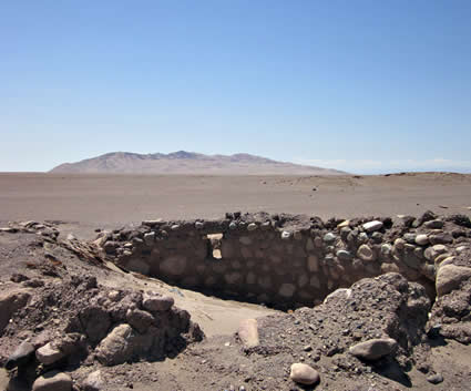
Because of the
drifting sands, much of the site is now covered up again. However, what is
visible today (2011) is still impressive and interesting. The site is located
at an altitude of about 1150 m O.D. and is roughly 80 km inland. The low ruins
are barely visible from the dirt road to Tamentica and therefore easily missed.
The settlement is situated on a vast plain cut by the Quebrada de Guatacondo.
At this point however, the Quebrada does not form a valley but forms a shallow
gully of about 2 m deep. At this point the gully is called Quebrada de
Guatacondo, while further upstream and east of Cerro Challocollito the gully
becomes more and more a valley. This stretch between Cerro Challocollito and
Tamentica is sometimes called Quebrada de los Pintados, although Cabello &
Ajata (2010: Plano 1) mention a (different?) Quebrada de Pintados further south.
About 5 km to the north of the village ruins the isolated group of hills called
Cerro Challacollo (1573 m. O.D.) is clearly visible.
Figure
1. Map of the surveyed area (100 m contour-interval). Drawing by Maarten van
Hoek
(based on the map by Clarkson,
Johnson, Johnson, Briones & Johnson 1999: 21).
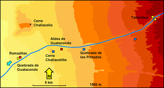
There are other important
archaeological remains in this area (Figure 1). About 9 km to the east of
Ramaditas is another ancient settlement (red square in Figure 1) called Aldea
de Guatacondo. On the eastern slopes of Cerro Challocollito (6.5 km east of
Ramaditas) is a small group of geoglyphs (blue square), while 13 km east in the
Quebrada de los Pintados are a few geoglyphs on a north facing ridge that overlooks
the Guatacondo valley. They are rather easily visible from below. The most
important group of geoglyphs however occurs at about 18 km east of Ramaditas. These
geoglyphs are invisible from Guatacondo valley floor as they are located about
1400 m south of the valley and about 100 m higher. They also appear on a north
facing ridge and overlook an ancient north-south road. More groups of geoglyphs
are found along this route. Importantly, 20 km ENE of Ramaditas is the well
known petroglyph site (yellow squares) of Tamentica that will be discussed
further on. East of Tamentica are several other rock art sites (rock paintings
and petroglyphs) that have been studied in detail by Gloria Cabello & Rolando
Ajata (2010). However, none of the images at these sites show definite parallels
to the Ramaditas imagery.
The plain on
which Ramaditas is situated only very slightly slopes to the SW. The area
around the settlement consists of sands and fine gravel, while at certain places
concentrations of somewhat larger boulders (of uniform rock type) occur. Directly
to the W and SW of the village is an area where agricultural fields with irrigation
systems are still visible. These fields also exist at many other parts of this
vast plain, especially to the NE of Ramaditas, where also low, circular
structures are visible. The village itself comprises a number of circular/oval houses
that are clustered together (like nearby Aldea de Guatacondo and more distant Tulor
near San Pedro de Atacama) and a number of isolated houses (Ajata 2010).
Many of the walls have been reduced to low, circular ridges in the sand. The
walls that are still standing are up to two metres high and originally would
have been capped bay a construction of reed (rama). A reconstructed model-house of such a dwelling can be
visited at Tulor, south of San Pedro de Atacama. Some of this reed is still
lying around, for example in the isolated house with the ‘rock art’. The wood
to support these roofs came from a nearby forest, now completely disappeared,
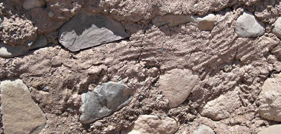
but several pieces of wood are still lying scattered around. The walls have
been made by adobe bricks (Figure 2) and/or by cementing together fairly large
boulders with clay from the riverbed. These boulders are of various types of
stone and most are rounded (water-worn). They probably have been collected from
a nearby source of river cobbles. Several house ruins still show door openings,
small windows and even a stair.
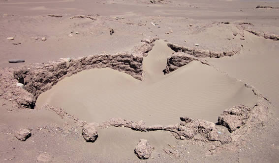
Figure
2. One of the houses at Ramaditas, Chile.
Photograph by Maarten van Hoek.
Interestingly, the
walls of the dwellings contain several types of anthropic markings. First, at
least one section of a wall clearly displays finger flutings (acanalado
por dedos). Flutings are lines that human fingers leave when drawn
over a soggy surface, like wet clay. Although they form groups of parallel
lines, these markings probably have no specific meaning and represent no form
of ‘rock’ art but simply indicate that the clay that people used to cement the
cobles together had been applied with their fingers (Figure 3). They may have
been left there because of a decorative aspect, although it is even possible
that they appear on a section of the wall that has been repaired (possibly even
in very recent times).
Figure
3. The ‘finger flutings’ at Ramaditas, Chile.
Photograph by Maarten van Hoek.
Figure
4. Some of the ‘finger holes’ at Ramaditas, Chile.
Photograph by Maarten van
Hoek.
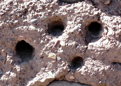
Several other
sections of walls show small holes made by people who have poked holes into the
clay with their fingers (Figure 4). The holes thus created show no pattern and
may possibly have been made just for fun. However, Cabello & Ajata suggest
that some of them may represent simple ‘faces’ (2010: 5). Also a few figurative
markings in the clay have been reported by Cabello & Ajata (2010: 5 - see Lámina 2:D, 2:F, 2:G and 2:H), as well
as two stones with traces of paint (2010: 6 - see Lámina 3:C and 3:D). The last type of anthropic markings concerns the
two ‘petroglyph’ stones that will be discussed now.
Ramaditas’ ‘Rock Art’
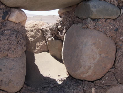
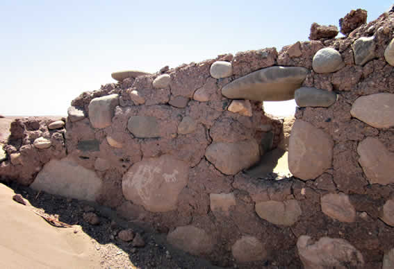
The two boulders with ‘petroglyphs’ have
been cemented in into the inner wall of the northern arc of an isolated house
(Figure 5), labelled Recinto 17 by
Cabello & Ajata (2010: Plano 2). Recinto 17 is situated only a short
distance to the W and SW of the two main clusters of houses. The larger Boulder
(1) is found between the door opening and a small window; the smaller Boulder (2)
forms the right hand ‘post’ of that small window (Figure 6). Importantly, both
Boulders are not placed at the base
of the wall.
Figure
5. The north wall of Recinto 17 at
Ramaditas, Chile. In the background is Cerro Challacollo.
Photograph by Maarten
van Hoek.
Figure
6. The north wall showing the two decorated boulders at Recinto 17 at Ramaditas, Chile. Photograph by Maarten van Hoek.
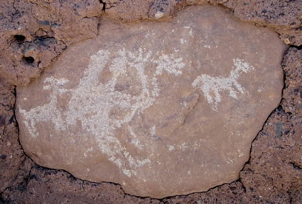
Boulder 1: The larger boulder is of a yellowish-pink colour and is now found
about 15 cm above present day soil level (base of the stone to ground level),
although in reality the distance would have been greater since the room has
partially been filled up with drift sand. The visible part of its surface
measures 33 cm in height by 44 cm in width. On its vertically oriented surface
are three petroglyphs (Figures 7 and 8). There are two fully pecked, laterally
depicted zoomorphs, each showing four legs and ears. Both look to the right
(for the observer). The left-hand zoomorph is about 8 cm in length and has a tail
that is pointing upwards while it seems to show an open mouth. However, the
lower jaw could also represent a short rope attached to the anthropomorph. The
right-hand zoomorph measures 9 cm in length and has a tail that curves
downwards. It seems to have an open mouth, but not as clearly as the other
zoomorph. These two zoomorphs probably represent images of camelids.
Figure
7. Boulder 1 at Recinto 17 at
Ramaditas, Chile.
Photograph by Maarten van Hoek.
Figure
8. Drawing of the images on Boulder 1 at Ramaditas, Chile.
Drawing
by Maarten van Hoek.
In between the two zoomorphs is a
petroglyph of an anthropomorph, again depicted in profile and also looking to
the right (for the observer). Also this figure has been fully pecked
(disregarding small and randomly distributed un-pecked areas). The
anthropomorph is 22 cm in height and measures 16 across. Several features are
interesting. First of all the anthropomorph seems to carry something on its
back, which may indicate that he is a traveller (backpacker). The anthropomorph
has a rather long neck and a small head with a short appendage from the top.
There are no facial features. It has also two legs and two arms that clearly
show splayed fingers. One hand may have four fingers; the other may have six (in
analogy with the pair of feet on panel OFA-01-02 at Ofragía, Chile: the left
foot has six toes, while the right foot has only four toes).
Boulder 2: At about 55 cm to the right of Boulder 1 is the second boulder of
similar colour, which forms part of a small window. The base of the stone is
about 50 cm above present day soil level and measures 29 cm in height by 28 cm
in width. It features only two petroglyphs, both less clearly and very
superficially pecked (Figures 9 and 10). The most obvious petroglyph certainly
represents a biomorphic figure and probably is an anthropomorph. It measures 22
cm in height. It cannot be determined with certainty whether the figure is intended
to be observed laterally or frontally, although the position of the two short legs
suggests that the figure has been depicted to be viewed frontally. In between
the legs is a short, downward pointing appendage. This might indicate male gender. The ‘head’ is directly attached to the
body; there is no neck. The ‘head’ is a large circular pecked area showing no
facial details. Emerging from the shoulder areas are two curved lines of dots
that might represent the ‘arms’. The
body is almost fully pecked, but an area to the right of the main body mass may
represent something else (an arm?, a backpack?, a spiral-like appendage?). The
other marking on this boulder is a small, circular pecked area to the right of
the biomorph.
Figure
9. Boulder 2 at Recinto 17 at
Ramaditas, Chile.
Photograph by Maarten van Hoek.
Figure
10. Drawing of the image(s) on Boulder 2 at Ramaditas, Chile.
Drawing
by Maarten van Hoek.
Interpretation
The biomorph on Boulder 2 is too
amorphous to be interpreted with any certainty. The anthropomorph on Boulder 1 together
with the two zoomorphs may depict a scene in which a specific person
accompanies two animals into a certain direction (into his house?). Such a
person may have been a shaman or a pochteca,
an Andean traveller/trader who is often carrying a backpack and other
paraphernalia, like a flute (Van Hoek 2005: 28). Interestingly, the curved arms
and the empty hands are placed in a very specific position, reminiscent of many
other petroglyphs in the Desert Andes where biomorphs (anthropomorphs and zoomorphs) are ‘playing a wind
instrument’. Several of the aforementioned biomorphs in such a specific
position do not hold a ‘wind
instrument’. Their hands are completely empty, like the splayed hands of the
enormous ‘monkey’ geoglyph on the Nasca Pampa in Peru. I have suggested earlier
that these ‘empty-handed’ biomorphs may hold an ‘invisible’ object, like a
flute (Van Hoek 2005). This might be
true for the anthropomorph on Boulder 1 as well.
Interestingly, there is also a groove
that unites the genital area of the anthropomorph with his arms. This groove might represent an erect phallus. It is now
generally accepted that the Andean flute may only be played by males (Van Hoek
2005: 26) and indeed several (but definitely not all) petroglyphs of ‘flute players’ in the
Desert Andes show some indication of male gender (Van Hoek 2005: Fig. 6). Interestingly,
there are many petroglyphs in the Southwest of the United States where
‘flute-player’ petroglyphs have an (erect) phallus (as well as being ‘humpbacked’).
Two examples, both almost analogous to the Ramaditas figure on Boulder 1, are
found in the Galisteo Basin, New Mexico, USA (Slifer 2000: Plate 20) and at the
enormous Three Rivers site, also in New Mexico (Van Hoek 2010: Fig. 18.11). These
petroglyphs are found no less than 7330 km NW of Ramaditas and although a direct cultural relationship is
impossible, the distant figures still may share a similar symbolism. If we
accept that also the biomorph on Boulder 2 represents a male, we might conclude that this specific house
at Ramaditas had been inhabited by a male (gendered?) person. It might even be the dwelling of the shaman
of this village.
Dating the ramaditas ‘petroglyphs’
In the Introduction it became clear
that Ramaditas is one of the earliest occupation sites in the Guatacondo
District. The complex probably dates from 500 B.C. to A.D. 0., the era when
large village-farming communities first appear in this sector of the Andes. However,
Cabello & Ajata (2010) refer to the work of Rivera, Shea, Carevic &
Graffam (1995-1996) and mention a date of 90 B.C.. There now are four
possibilities regarding the dating of the Ramaditas ‘petroglyphs’.
1). The first option is that the two
petroglyph boulders were found locally and - together with many other (undecorated)
boulders - were used to construct the walls of Recinto 17. In this scenario, these boulders had already been
decorated with images (long?) before the village was founded. Thus the images
would be older than the construction of the village and initially they would have
been true petroglyphs. The boulders were incorporated into the wall in such a
way that the images remained visible. This may have been done for decorative
reasons, but it is more likely that the imagery was important to the person(s)
residing in this dwelling. Their specific positions a short distance above
ground level seems to point to intent. In this case rock art may have been turned into architectural art.
2). A second option is that the
images were made when the village already existed. The manufacture of the
images may have been done in the field, at the spot where they were found, or
the boulders were first transported to the village, decorated there and
subsequently built into the wall. In this case there is ‘only’ question of architectural art.
3). The third option is that a
person who inhabited the dwelling (or someone else) made these images as signs
of his (or her?) function after they
were fixed into the wall. Especially Boulder 1 is large enough and firmly fixed
into the wall to receive the blows of a stone implement. However, the position
of Boulder 2 is much less fixed and this may confirm the idea that the
boulder(s?) was (were) already decorated (which seems to confirm option 1 or
option 2). Also in this case the images represent architectural art rather than rock art and would probably date from
500 B.C. to A.D. 0.
4). A fourth option departs from the
idea that the images were made after the abandonment of the village. The houses were empty and travellers might have
used the ruins as temporary shelters. Someone may have executed these images on
those two boulders during such a stay. Again, the rather unstable position of
Boulder 2 argues against this idea. In this case the images may be regarded as rock art and could date from any time
from A.D. 0 to the Spanish Invasion.
From these four options it proves
that the occurrence of a ‘petroglyph’ boulder built into a dateable structure
provides no indication of the age of the imagery,
as the images at Ramaditas do not occur in a sealed context. Importantly,
parts of the clay (especially a small part with two finger-holes) still cover
Boulder 1, while other parts (that once might have covered a portion or all of the ‘petroglyphs’) may have fallen off.
Unfortunately it cannot be ascertained to date if indeed the clay once covered
(part of or all of) the ‘petroglyphs’ of Boulder 1. If the clay once covered
the whole scene (which, because of its slightly domed surface, is unlikely), it
would indicate that the builders only used the boulder and did not have the intention to (re)sanctify its imagery.
However, it would have been quite impossible to completely cover Boulder 2 with
clay, being a corner-stone of a small window.
Another interesting fact is that the
surfaces of the boulders visible today and their images hardly seem to have been patinated. This may indicate that the
petroglyphs were manufactured not that long before (option 1) or during (option
2) the construction of the village. After being incorporated into the wall of
the house they became protected from the sun, even when the site was abandoned.
The now vertically placed surfaces of the two boulders notably face south and
only at the peak of the summer they will catch some sun light, but never
perpendicularly (because of the position of the site on the Southern Hemisphere:
21º S and only 268 km north of the Tropic of Capricorn).
Graphical context
Unfortunately, the graphical content
of only two boulders offers too small a basis to definitely link these
‘petroglyphs’ with other graphical representations in the direct neighbourhood or
indeed in a much wider area. The two small ‘camelids’ show no specific detail
or style and can be of any prehistoric date. Similar representations of
‘camelids’ occur at many places in the Desert Andes. Also the rather amorphous ‘biomorph’
on Boulder 2 shows no specific features.
Only the anthropomorph on Boulder 1
could be used for comparison. Fortunately, Ramaditas is located at the western
fringe of an area that is rich in rock art and also has a number of geoglyph
sites (see Figure 1). However, none of the anthropomorphic figures of the
geoglyphs known to me has any resemblance with the anthropomorph on Boulder 1. Most
distinguishing are the ‘backpack’, the possible phallus and the specific
position of the arms and hands. Although there are several rock art sites further
east in the Quebrada de Guatacondo (Cabello & Ajata 2010) only the
graphical content of the site of Tamentica-1 proved to be useful to compare the
Ramaditas anthropomorph with.
Tamentica-1
Tamentica-1 (the site at the north side of the bottleneck in the
Guatacondo Valley) no doubt once was a very important rock art site and it still is. However, I was shocked
to see how violated this sacred site was at time of our visit. Many stones were
displaced, badly disturbed and severely damaged. Another disappointment was
that the newly built Site Museum was closed and - because it was said that vandals
stole many items from the museum - it probably will remain closed.
Fortunately, many of the petroglyphs
are still visible. Among these are several fully pecked ‘camelids’, more or
less of the same type as seen on Boulder 1 at Ramaditas. There are also many
anthropomorphic figures, and what is more important, several of those figures
proved to have a ‘load on their backs’ (or simply are ‘humpbacked’). Especially
this ‘backpacker’ theme links Tamentica with Ramaditas. However, this parallel
offers no conclusive proof that the Tamentica manufacturers are also
responsible for the imagery at Ramaditas. Notably, petroglyphs of ‘backpackers’
occur at several rock art sites in the Desert Andes (for instance at Ariquilda
in the Quebrada de Aroma and at Calaunza in the Codpa Valley of Chile and at Miculla
and Huancor in Peru). However,
Tamentica seems to be the site with the biggest number of such ‘backpacker’
figures. Moreover, several anthropomorphic figures at Tamentica have their arms
in unusual positions. One such figure is more or less in the same position as
the anthropomorph on Boulder 1, but it has no hands. Unfortunately this cannot
be checked anymore as this specific boulder has severely been damaged (Figure
11). A complete drawing of this panel appears in the book by Grete Mostny
Glaser & Hans Niemeyer Fernández (1983: Fig. 45). Also this anthropomorph
is associated with a small, pecked ‘camelid’.

Figure 11. Damaged boulder at Tamentica-1,
Chile. Photograph by Maarten van Hoek.
Drawing by Grete Mostny Glaser &
Hans Niemeyer Fernández (1983: Fig. 45).
Several ‘backpackers’ at Tamentica
seem to hold object (staffs?), while a few panels show scenes involving
‘backpackers’, walking in a row (as on Bloque 32 - Panel I), or even when standing in a raft. At least one ‘backpacker’ at
Tamentica (on Bloque 7 - Panel D) seems
to be phallic and has a load on its
back that is similar in shape to the load on Boulder 1 (Figure 12). On Bloque 40 are two profile figures in a
row that seem to ‘play a wind instrument’ and one of them seems to carry a
‘backpack’. Remarkably, none of the anthropomorphs that I inspected at
Tamentica-1 clearly displays (splayed) hands (like the anthropomorph on Boulder
1). It is certain that the petroglyphs at Tamentica date from different
periods. For example, the many raft-petroglyphs are said to date from the Arica
Culture (A.D. 1000 to A.D. 1500) (Mostny Glaser & Niemeyer Fernández 1983:123),
but other images are said to date from around B.C. 100 to A.D. 100 (Mostny
Glaser & Niemeyer Fernández 1983).
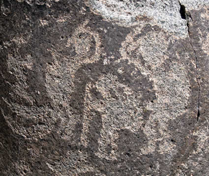
Figure 12. Detail of a boulder at
Tamentica-1, Chile, showing three ‘backpackers’.
Photograph by Maarten van
Hoek.
Conclusions
What are the facts in this story?
First of all, it is certain that the village of Ramaditas is one of the oldest agrarian
settlements in the Atacama Desert. Its foundation probably dates around 500
B.C.. The second fact is that two boulders - incorporated into the northern
wall of an isolated house at Ramaditas - bear pecked images of altogether four
biomorphs. A third fact is that further east several expressions of prehistoric
art are found (geoglyphs and rock art) and that especially the rock art
repertoire of Tamentica has certain elements in common with the anthropomorph
on Boulder 1 at Ramaditas. The rest of the story involves hypotheses only.
It is also a fact that we do not know what the Ramaditas images stand
for. It is possible however - because of the ‘backpack’ - that the
anthropomorph on Boulder 1 represents a Pochecta,
an Andean merchant-traveller. In addition to this suggestion it is possible
that - because of the phallus and the position of the hands - the figure
represents ‘a shaman who is playing an invisible flute’. The presence of
‘backpackers’ and ‘flute players’ at the rock art site of Tamentica-1 seems to
confirm the hypotheses postulated in this survey. A plausible theory (but still
a theory) would be that Recinto 17
belonged to a (travelling?) shaman and that his function was symbolised by the
imagery in his or her house.
It is also a fact that we do not
know exactly when the four
‘petroglyphs’ were made (especially petroglyphs are notoriously difficult to
date). In this respect I explored four options. However, it is very likely that
the images date from around 500 B.C. (if we accept 500 B.C. as roughly the date
that the house was built). Unfortunately, it is - in general - too easily
accepted that also the rock art in the vicinity of or incorporated in
prehistoric structures has been manufactured by the builders/occupants of those
structures. However, it is not at all certain if indeed the residents of those
settlements were also the manufacturers of the imagery on the rocks; it is possible
but indecisive. This uncertainty also applies to the built-in images at
Ramaditas.
There are several other sites in the
Atacama Desert where rock art is found directly associated with a settlement. I
mentioned Tarapacá Viejo, Camiña, Jamajuga, Vinto, Millune, Achuyo, Suca and
San Lorenzo. However, in those cases none of the decorated rocks has been incorporated into a house in the same way as at Ramaditas. Despite this distinctive
difference, however, the key question remains unsolved. Were the Ramaditas images
once true petroglyphs, or have they been made to serve as architectural art,
i.e. have they been made exclusively to be incorporated into the wall of Recinto 17? We will probably never know.
Acknowledgements
I am most
grateful to Rolando Ajata López who provided me with much useful information
about Chilean archaeology, including an unpublished report on the rock art of the
Guatacondo Valley of northern Chile. Rolando Ajata López has also been so kind to read and comment on the
draft text, but of course the contents of this paper are completely my
responsibility. We are also indebted to our guide who expertly showed us the
rock art site of Tamentica and who took us to the ‘petroglyphs’ at Aldea de
Ramaditas. I also thank my wife Elles for her assistance during our surveys in Guatacondo.

—¿Preguntas,
comentarios? escriba a: rupestreweb@yahoogroups.com—
Cómo
citar este artículo:
van Hoek, Maarten. Aldea de Ramaditas, Chile: Architectural Art or Rock Art?
En Rupestreweb, http://www.rupestreweb.info/aldearamaditas.html
2011
BIBLIOGRAPHY
Ajata L., R. 2010. Plano de Aldea Ramaditas, Quebrada de Huatacondo. In: PicasaWeb: https://picasaweb.google.com/rolandoajata/Mapas#5449418000125616658
Baied, C. A. 2007. Chungara.
Vol. 39-1. pp 135-136. Revista de Antropología Chilena.
http://www.scielo.cl/scielo.php?pid=s0717-73562007000100009&script=sci_arttext
Briones M. G. L.
& R. Ajata L. 2004. Video Documental elaborado en el Proyecto Arqueologico "Puesta en
Valor y Protección del Yacimiento Arqueológico de Tamentica". In YouTube: http://www.youtube.com/watch?v=8PkV6Pufc3Q&feature=related
Cabello, G. & R. Ajata. 2010. Revisitando el arte rupestre
de Huatacondo. Informe año II. Unpublished
Project Paper. Proyecto FONDECYT -
1080458.
Clarkson, P. B., G. Johnson, W. Johnson, L. Briones & E. Johnson. 1999. Low-cost high-return
aerial photography in archaeology. Inora, Vol. 24. pp 21-25.
Echevarría López, G. T. & Z. Valencia
García. 2009. The ‘llamas’ from Choquequirao:
a 15th-Century Cusco Imperial rock art. Rock
Art Research. Vol. 26-2. pp 213-223. Melbourne.
Briones M, L. &
R. Varela G. 2006. Museo Arqueológico San Miguel de Azapa: Expociones. Universidad de
Tarpacá. http://www.uta.cl/masma/expos/index.htm
Mostny Glaser, G.
& H. Niemeyer Fernández. 1983. Arte Rupestre
Chileno. Serie El Patrimonio Cultural Chileno. Colección Historia del Arte
Chileno. Publicación del Departamento de Extensión Cultural del Ministerio de
Educación.
Rivera, M. A. 2002. Historias del Desierto: Arqueología del Norte de Chile. Editorial
del Norte, La Serena, Chile.
Rivera, M. A. 2005. Arqueología del Desierto
de Atacama. La etapa Formativa en el Área de Ramaditas/Guatacondo. Santiago de Chile: Universidad Bolivariana
(Colección Estudios Regionales y Locales).
Rivera, M., D. Shea, A., Carevic & G.
Graffam. 1995-1996. En torno a los orígenes de las sociedades complejas andinas: excavaciones en
Ramaditas, una aldea Formativa del desierto de Atacama, Chile. Diálogo Andino. Vol. 14/15: 205-239.
Arica.
Sepúlveda, R. M.
A., Á. L. Romero Guevara & L. Briones. 2005. Tráfico de caravanas, arte rupestre
y ritualidad en la Quebrada de Suca (extremo norte de Chile). Chungara, Revista de Antropología Chilena. Vol. 37-2. pp 225-243.
Slifer, D. 2000. The serpent and the sacred fire. Fertility images in Southwest rock art.
Museum of New Mexico Press, NM.
Trincado, P. 2008. http://www.flickr.com/search/?w=all&q=Jamajuga+&m=text
Uribe, R. M. 2006. Acerca de complejidad, desigualidad
social y complejo cultural Pica-Tarapacá en los Andes Centro-Sur (100-1450
dC). Estudios Atacameños. Vol 31, pp
91-114. Universidad Catolica del Norte, San Pedro de Atacaman, Chile.
Valenzuela, D., M. C. Santoro & Á. Romero. 2004. Arte rupestre en
asentiamentos del Período Tardío en los valles de Lluta y Azapa, Norte de
Chile. Chungara, Revista de Antropología Chilena. Vol. 36, Nº 2, 2004. pp 421-437.
Van Hoek, M. 2005. Biomorphs
‘playing a wind instrument’ in Andean rock art. Rock Art research. 22-1, pp 23-34. Melbourne, Australia.
Van Hoek, M 2007. Petroglifos Chavinoides cerca de
Tomabal, Valle de Virú, Perú. Boletín de
SIARB, Vol. 21, pp 76-88. La Paz, Bolivia.
Van Hoek, M 2009. Egyptian temple petroglyphs. SAHARA.
Vol. 20. pp 171-176. Milano, Italia.
Van Hoek, M 2010. Mogollon Rock Art and the Status of the ‘Flute
Player’. In: Proceedings of the XV World
Congress UISPP. Lisbon. BAR International Series, pp 161-173, Archaeopress;
Publishers of British Archaeological Reports, Oxford, England.
Van Hoek, M. 2011. Banda Florida. An overview of a rock art site in La Rioja,
Argentina. In: Rupestreweb. http://www.rupestreweb.info/bandaflorida.html
Vilches, F. & G.
Cabello. 2006. “De lo público a lo privado: el arte
rupestre asociado al complejo Pica-Tarapacá”. Actas del V Congreso Chileno de Antropología, San Felipe 2004.
[Rupestreweb Inicio] [Introducción] [Artículos]
[Noticias] [Mapa] [Investigadores] [Publique] |